“Too Unthinkable,” the Complete Destruction of the St Lucie River, SLR/IRL

The blue-green algae, the cyanobacteria–sometimes toxic— that we first saw in aerial photos over Lake Okeechobee weeks ago, is not only here, it is everywhere…our river has been made completely fresh by our government. Now the algae is blooming fluorescent green-blue, dying a putrid brown-green, flowing out of our inlet, and poisoning not only or rivers’ shores but our beaches.
On the widest level, this is a health hazard brought upon us by a “knowing government.” Our state, federal, and local governments have seen this coming for years. The slow and steady destruction of the St Lucie River/Indian River Lagoon is well documented.
The St Lucie River was first declared “impaired” by the state of Florida in the year 2002. I have been blogging about this for four years.
(https://www.dep.state.fl.us/southeast/ecosum/ecosums/SLE_Impairment_Narrative_ver_3.7.pdf)
Now, in 2016, all of Martin County’s beaches and the southern most beach of St Lucie County are closed. Palm City; Stuart; Rio; Sewall’s Point, Jensen. All waters are off limits. “Don’t Touch the Water.” –A health, safety and welfare issue for the people, a nightmare for local government, and a complete environmental and economic disaster for us all.
Included for purposes of documentation– to be added to the thousands of other posts on social media this weekend— I share the following, some that were shared with me…Divided into 8 sections: 1. Algae in the waves at Bathtub Beach, by JTL; 2. algae aerials at C-44, S-80, and S-308, by Dr Scott Kuhns; 3. Lake Okeechobee and St Lucie River’s extensive algae bloom, by jet pilot Dave Stone, and local pilot Ron Rowers; 4. Rio, a residential disaster, Jeff Tucker; 5. Sewall’s Point as seen from the Evan’s Cray Bridge with a river full of algae by walker Tracy Barnes; 6. Rebecca Fatzinger’s duck eating algae; 7. my Uncle Dale Hudson’s lead to Snug Harbor’s Marina “a multimillion dollar disaster,” and 8. Really blue-algae at Central Marina, Stuart/Rio.
The outpouring of the public is immense, and the powers that be, must look our way. Document, call, write, demand, and VOTE.
Jacqui
I. Bathtub Beach, JTL

Link to video: (https://www.youtube.com/watch?v=bYo6RNg3a1Y)
II. Photos by Dr Scott Kuhns Lake Okeechobee, Port Mayaca (S-308), St Lucie Locks and Dam (S-80) and C-44 canal. All aerial photos taken 6-25-16.


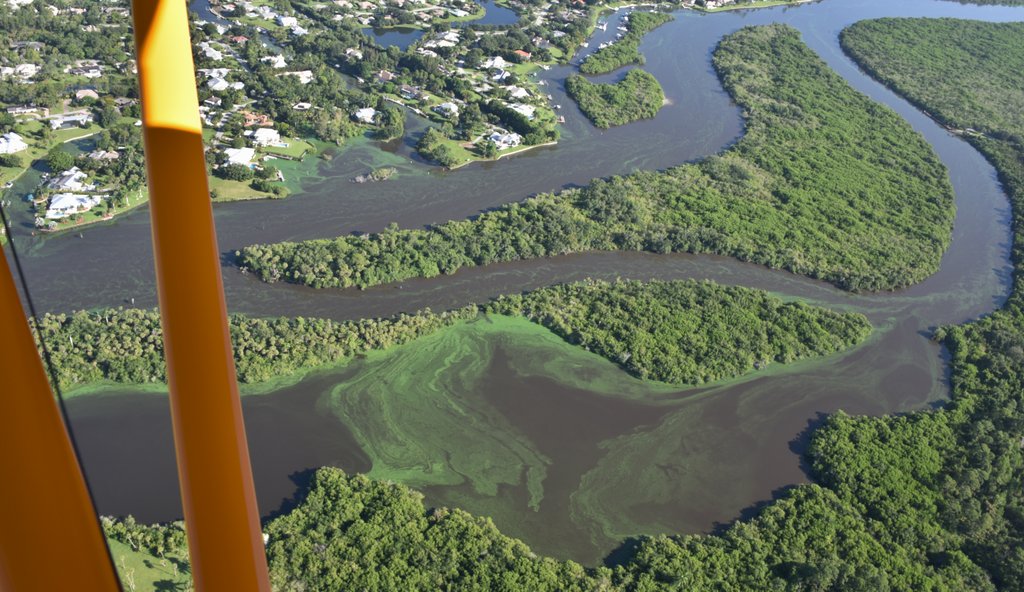
III. Professional jet pilot Dave Stone coming from Lee County to Martin County 6-26-16.
Aerial Video St Lucie River approaching North River Shores at 700 feet.
Link to video: (https://www.youtube.com/watch?v=8WLU6uLUKHo)


IV. Jeff Tucker, Rio


Video link Jeff Tucker, Rio: (https://www.youtube.com/watch?v=9DG687c8mgc)
V. Tracy Barnes walking over Evans Crary Bridge from Stuart into to Sewall’s Point

Video of Sewall’s Point walking over bridge. River full of algae.
Link to video (https://www.youtube.com/watch?v=6pEg9OPuN2w )
VI. Rebecca Fatziner’s duck in SLR

VII. Dale Hudson, alerted Ed and I to Snug Harbor Marina where we took these photos yesterday.

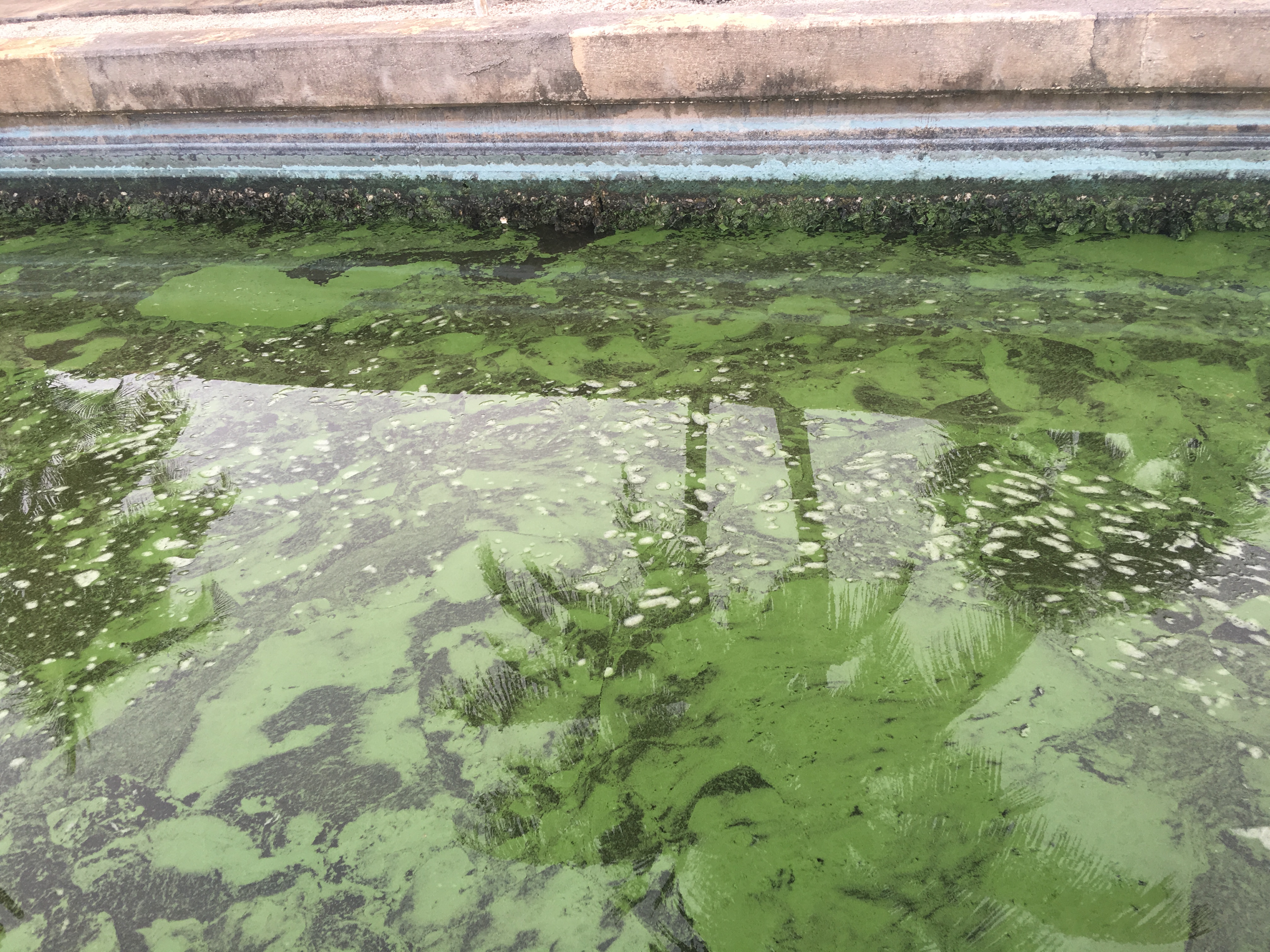

VIII. *Central Marina, Rio/Stuart blue algae


“Too Unthinkable”
Blog from 2014 on impairment of SLR: (https://jacquithurlowlippisch.com/2014/03/26/impairment-of-the-st-lucie-riverindian-river-lagoon/)
*blue algae photos, #8, added to this post later in afternoon on same date this was originally published. JTL